Lake Beulah Dam History and Agreement
Negotiating an Easement Agreement for the Lake Beulah Dam
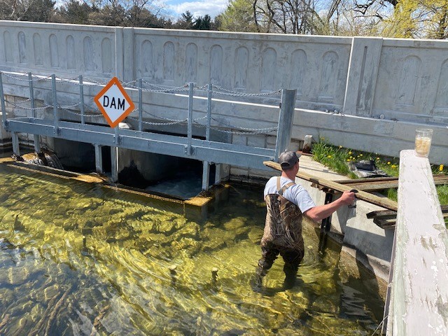
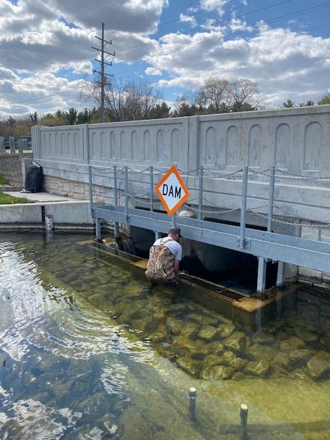
The earthen outflow dam on Lake Beulah under Walworth County J was constructed over 100 years ago to raise the level of the lake and form one contiguous lake from the original three separate lakes (Mill Lake, Crooked Lake and Long Lake)
Over the years, property owners built their homes on the land that forms the structure of the dam and, therefore, became "owners” of the dam with rights to restrict access of the DNR, Walworth County and the Lake Beulah Management District to inspect, maintain, and, as necessary, repair the dam structure and spillway. Obviously, failure of the dam would be catastrophic for our lake and for residents in the "flood plain" below the dam.
A preliminary meeting was held in January, 2001 between property owners, LBMD and a DNR Dam Safety Engineer to seek a solution to DNR and LBMD funded inspection reports in 1993 and 2000 which raised concerns about the lack of on-going dam maintenance. The DNR has rated the Lake Beulah Dam as a “high hazard” dam because of its age and the lack of on-going inspections and maintenance.
The DNR recommended that the property owners and LBMD prepare an agreement similar to one signed in 1995 transferring ownership of the Little Muskego Lake Dam from a single property owner to the City of Muskego. However, in our case, the number of owners involved and the need to include the Walworth County Highway Department (who maintain County J highway) in any agreement, made negotiations difficult. Furthermore, there were no records indicating the exact boundaries of the dam.
After much discussion between the parties, the owners agreed in 2006 to select one owner, Marshall R. Stack, as their representative. Paul Didier, then President of the Lake Beulah Protective and Improvement Association, was then able to arrange a meeting in April 2006 at the dam site between LBMD Commissioners Skotarzak and Dow, Paul Didier, Marshall Stack and other owners, Bill Sturtevant (DNR Dam Safety Engineer) and Michael Cotter (Deputy Corporation Counsel of Walworth County). At that meeting, Mr. Sturtevant established the boundaries of the dam as a key first step in negotiating an agreement. Mr. Sturtevant also confirmed that LBMD was a co-owner of the Dam by virtue of our right-of-way to the weed harvester and equipment storage shed.
Follow-up meetings were held during 2006 with the owners, Mr. Cotter and representatives of the Walworth County Highway Department to agree upon County employee access, maintenance and dam repair within thirty-three feet on either side of the Highway J centerline (which includes trees, shrubbery, and the concrete box culvert and wingwalls of the dam) as recommended by the DNR.
We thank Marshall Stack and Paul Didier for their leadership and dedication in assisting all the parties in the negotiations leading to approval of the Agreement.
The final Agreement was signed by all owners of property within the Dam boundaries, Chairman David Skotarzak of LBMD and Ann Lohrmann, Walworth County Board Chairperson. The approved Agreement with Exhibit A (A Dam boundary map prepared by Paul Didier in November, 2006) and Exhibit B (A Survey Map prepared by RSV Engineering in September, 2007) was recorded by the Walworth County Register of Deeds office on October 4, 2007. Click on the Links below to view the Agreement and Exhibits.
Exhibit A MAP
Exhibit B MAP
AGREEMENT
Summary of the Lake Beulah Dam Agreement
The Owners: Grant to LBMD and its assigns a watercourse easement for inspection, construction, repair, maintenance and reconstruction of the Dam and the area within the boundaries of the Dam. The Owners are responsible for performing routine maintenance of their respective properties such as cutting trees, shrubs and grass and maintaining their allowed shoreline structures. The covenants of the Agreement “run with the land” and will apply to all future owners of property with the Dam boundaries.
The DNR: Will conduct periodic inspections and direct the Owners (including LBMD) and Walworth County to repair maintain or reconstruct the Dam as required. The DNR will approve all plans to repair or alter the Dam and grant necessary permits and approvals to conduct these activities.
Walworth County: Will repair, maintain and reconstruct the Dam within the Highway J right-of-way thirty-three feet from the highway centerline on either side of the highway as recommended by the DNR. LBMD will reimburse the County if the DNR recommends repair, maintenance and/or reconstruction of the Dam outside of the County right-of-way. The County will also prepare flood plain zoning, emergency action plans, operation/maintenance plans and dam spill lake capacity analyses in cooperation with LBMD. The County will also conduct training sessions for the implementation of these plans.